
CENTRAL VALLEY, Calif. – New images released by NASA reveal that the bed Tulare Lake Continues to recover land lost to drought and agricultural development in the region.
As of February 1 of this year, it can be seen that only a small part of the revived lake is visible from space. This area has increased dramatically, as shown in the second image where by April 30th the snowmelt has already begun to descend into the valleys.
The image on the right also shows the area of agricultural crops that are still submerged.
After strong storms in March, it was Tulare Lake They were acquiring the lands of the abarratoda for fertile land for crops. Since the 1920s, the rivers that feed the lake have been adulterated and diverted to agriculture and other uses. Since then, the Tulare Lake Bed has served the agricultural and ranching development of California’s Central Valley.
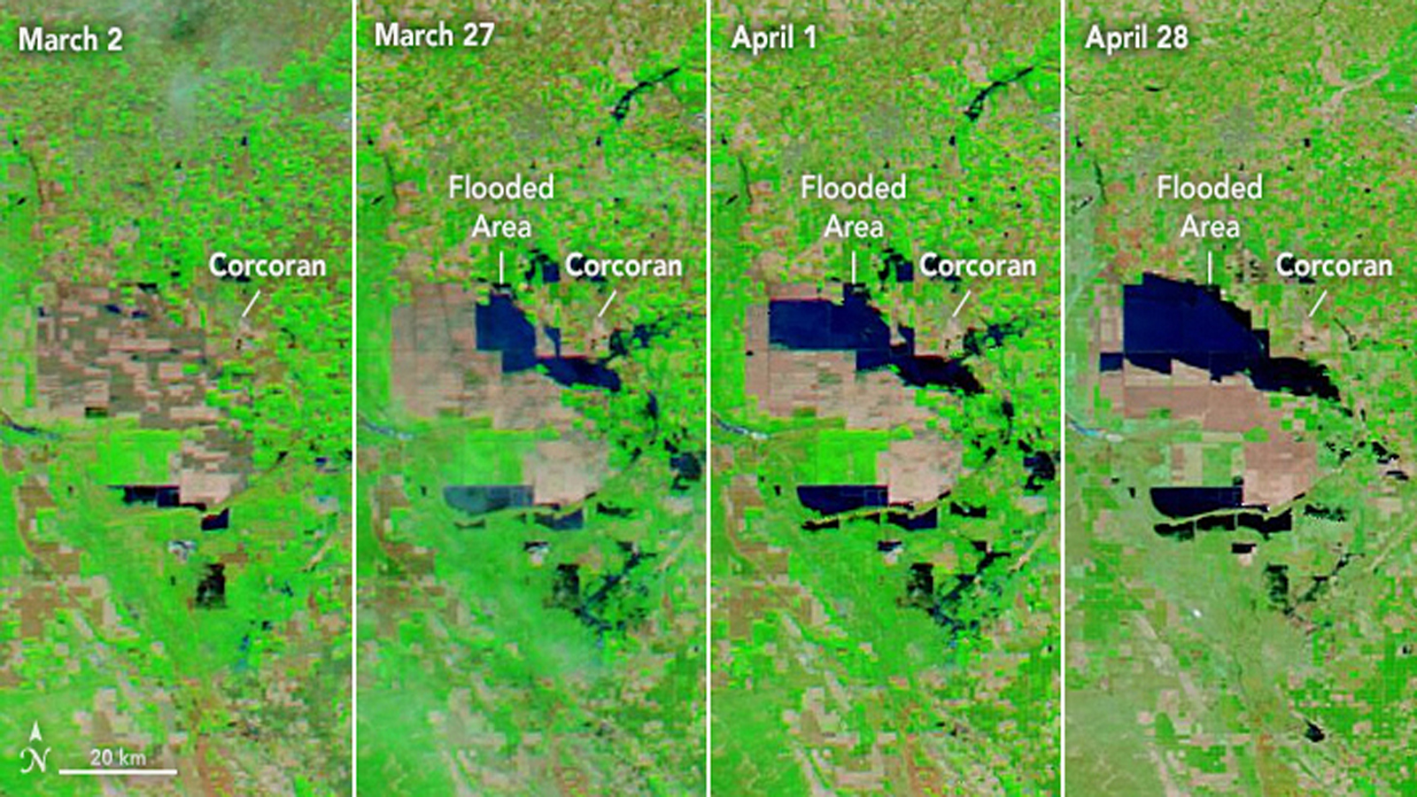
The images in the photo show the development of flooding in the Lake Tulare basin. Acquired by the Moderate Resolution Imaging Spectroradiometer (MODIS) captured by NASA’s Aqua satellite, between March 2 and April 28, 2023.
According to the California Department of Water Resources, the ice melt the state is experiencing is the largest in 70 years. In a water-snow layer measurement taken on April 1, it was 237% of the average.
Due to the rapid snow runoff, authorities have had to close some sections of the Kaweah, Tule, and Kern rivers as well as the Kings and St. John’s from the public due to the danger their waters pose.
The communities of Alpaugh, Allensworth, Corcoran, Porterville, Three Rivers, and Woodlake, among others, are under alert and evacuation orders due to the potential for flooding of rivers and lakes in the area.
Corcoran continues to be the population most at risk, as the city is located just 14.5 miles from the flooded area. Emergency teams and neighbors raised the height of the dam to 4 feet as a precaution.
National Weather Service authorities maintain a flood warning for sections of Kings, Fresno, and Tulare counties, primarily due to new water drainage being implemented at Pine Flat Dam.
At this time of year, temperatures are still not normal for the season. Officials from the Department of Water Resources said at a recent conference that the largest melting could be seen at the end of May, but the flooded area is expected to continue in this manner until 2024.


/cloudfront-us-east-1.images.arcpublishing.com/eluniverso/ESZCYCVTMHULRF4XLKFETXEN2U.jpg "The phrase about the origins of Argentina, Brazilians and Mexicans is critical of President Alberto Fernandez. International | News")

